By Bill Pan
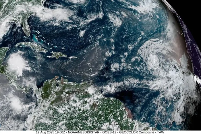
Hurricane Erin has rapidly intensified into a Category 5 storm as it travels north of Puerto Rico on Saturday, the National Hurricane Center said.
The first Atlantic hurricane of the 2025 season, Erin strengthened from a tropical storm to a Category 5 system in a matter of 24 hours. By late Saturday morning, its maximum sustained wind speeds had more than doubled to 160 mph.
Meteorologists expect Erin to veer west-northwest later Saturday and then turn north after the weekend, passing north of Puerto Rico and the Virgin Islands.
The storm’s core is projected to remain over open water without making landfall, but its sheer size could still bring heavy rains, flash flooding, and dangerous surf to the Caribbean and U.S. East Coast.
“By the middle of next week, Erin is forecast to at least double or triple in size, which will result in rough ocean conditions over the western Atlantic,” the National Hurricane Center said.
While Hurricane Erin does not appear likely to make a direct strike on the Leeward Islands, the Virgin Islands, or Puerto Rico, its outer bands are already beginning to affect the region. Forecasters said rainfall totals of 2 to 4 inches are expected through Sunday, with isolated areas seeing as much as 6 inches across parts of the Caribbean.
“Locally considerable flash and urban flooding, along with landslides or mudslides, are possible,” the hurricane center said.
As a precaution, the federal government has deployed more than 200 Federal Emergency Management Agency staff and other personnel to Puerto Rico, where a flood watch is in effect through Monday.
Puerto Rico Housing Secretary Ciary Pérez Peña said 367 shelters have been inspected and are ready to open if necessary.
Meanwhile, the Coast Guard announced Friday it had closed six seaports in Puerto Rico and two in the U.S. Virgin Islands to incoming vessels unless they had received prior authorization.
Erin is the fifth named storm of the Atlantic hurricane season, which runs from June 1 through Nov. 30. Tropical Storm Chantal made the first U.S. landfall of the season and brought high winds and deadly flooding to the Carolinas during the Independence Day holiday weekend.
The 2025 hurricane season is forecast to be unusually active.
Earlier this month, the National Oceanic and Atmospheric Administration (NOAA) updated its outlook, projecting 13 to 18 named storms with winds of at least 39 mph, of which five to nine could become hurricanes (74 mph or higher), including two to five that could reach major status (111 mph or higher).
In the Atlantic basin, a typical hurricane season will yield 14 named storms, of which seven become hurricanes and three become major hurricanes, the NOAA said.


