By T. J. Muscaro
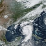
TAMPA—Hurricane Helene is now a major hurricane looking to make landfall in Florida’s Big Bend Thursday evening, according to The National Hurricane Center. Afterward, its center is expected to be within the Atlanta-Marietta metro area by 8 a.m. Sept. 27.
“The Air Force Hurricane Hunters found that the maximum sustained winds have increased to near-120 mph,” the National Hurricane Center stated in a special update released at 2:25 p.m. ET, making it a Category 3 Hurricane on the Saffir-Simpson hurricane wind scale.
Maximum sustained winds were only just recorded at 110 mph as of 2 p.m. ET on Sept. 26.
At that time, Helene’s center was spotted 195 miles southwest of Tampa, Florida, and hurricane-force winds (74 mph and greater) were recorded 60 miles out, and tropical storm-force winds (39–73 mph) extended 345 miles out.
At the update, it was 170 miles southwest of Tampa moving north-northeast at 16 mph.
The NHC said additional strengthening was expected before it makes landfall.
Previous reports forecasted Helene to become a Category 4 storm with winds over 130 mph.
The National Hurricane Center defines a major hurricane as one that has sustained winds exceeding 110 mph.
“Preparations to protect life and property should be rushed to completion,” the National Hurricane Center warned.
Regardless of core strength, Helene’s size and outward reach of tropical storm-force winds have already put the southeast United States under threat.
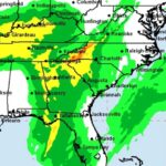
Helene is expected to drop 6 to 12 inches of rain across the southeastern United States and the southern Appalachian mountains, with isolated totals reaching as much as 20 inches.
Tornado and flash flood warnings have been issued and are in effect as of 2 p.m. in inland areas across Florida, Georgia, South Carolina, and North Carolina.
After landfall, Helene is expected to drop to a tropical storm as it crosses into Georgia, with winds up to 63 mph, and tropical storm-force winds extending out more than 120 miles northeast and more than 330 miles southeast.
The National Hurricane Center warned earlier of “catastrophic and potentially life-threatening flash and urban flooding, along with significant river flooding.”
“Numerous landslides are expected in steep terrain across the southern Appalachians,” it added.
It also said, “Considerable to locally catastrophic flash and urban flooding” is also likely for northern and northwestern Florida and the southeast United States through Sept. 27.
North Carolina’s Gov. Roy Cooper and Georgia’s Gov. Brian Kemp echoed those warnings of flooding and landslides during respective press conferences on Sept. 26.
On the coastlines, life-threatening storm surge continues to be expected, with as much as 15–20 feet predicted for the Big Bend.
Even though Helene is still currently offshore, most of Florida’s west coast is under tropical storm conditions. Its effects are already being felt as far away as North Carolina.
All or portions of those four states also remain under either a tropical storm or hurricane warning. Portions of eastern Alabama, including Dothan and Auburn, are under tropical storm or hurricane warnings.
A state of emergency has been declared by DeSantis, Kemp, and Cooper, as well as South Carolina’s Gov. Henry McMaster.
President Joe Biden has approved disaster declarations for Florida, Georgia, and North Carolina.
Graphics from the National Hurricane Center indicate that most of Florida’s peninsula is under Helene’s field of tropical storm conditions.
Sustained winds of 41 mph were recently recorded at Key West Naval Air Station, and a weather station in Tarpon Point, Florida. Wind gusts of 64 mph were recently recorded at Ft. Lauderdale/Hollywood International Airport, gusts of 56 mph were recently recorded in Naples, Florida, and gusts of 64 mph were recorded in Cocoa Beach.
Florida’s Gov. Ron DeSantis confirmed 14 tornado warnings were issued during the night as the storm’s outer bands moved across multiple southern counties, including Palm Beach and Collier counties.
Street flooding has been reported across the Tampa Bay region throughout the morning.
From the emergency operations center in Tallahassee, DeSantis told Floridians and members of the press on the morning of Sept. 26 that time was running out to evacuate and put hurricane plans into action.
“Every minute that goes by brings us closer to having conditions that are going to be simply too dangerous to navigate,” he said.
DeSantis was joined by Kevin Guthrie, executive director of the Florida Department of Emergency Management, who told residents, especially those in northern Florida surrounded by pine trees, to treat falling trees like tornado events.
“Pine tree snapping sounds an awful lot like fireworks or potentially gunshots,” he said. “So please make sure if you hear that act immediately, get to the interior portion of your home, away from glass, most likely a bathroom, and stay there until you hear that sound stop.”
Guthrie also urged those Floridians choosing to ignore evacuation orders and shelter in place to tell someone.
“Call somebody and tell them you’re sheltering in place,” he said. “That way there’s some type of check and balance there so that we know that you did not evacuate.
“Again, we don’t want you to shelter in place, but if you decide to do that, make sure you call a friend or a loved one outside the area and let them know. But don’t forget to call them after to let them know that you’re safe.”


