By Jack Phillips
The National Hurricane Center (NHC) said on Sept. 4 that a tropical weather system in the Atlantic Ocean will likely form into a stronger storm within the coming days
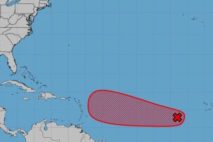
“Showers and thunderstorms associated with a tropical wave located over the eastern tropical Atlantic several hundred miles west-southwest of the Cabo Verde Islands have started to consolidate and become slightly better organized,” said an advisory released at 8 a.m. on Thursday by the Miami-based hurricane center.
Over the coming days, “environmental conditions are conducive for development of this system,” which will likely lead to the formation of a tropical depression later in the week or by the weekend as it moves to the west-northwest at 5 mph to 10 mph, according to the bulletin.
A tropical depression is a low-pressure area with winds of up to 38 mph, while a tropical storm has wind speeds of 39 to 73 mph. After the system reaches tropical storm status, it is given a name, while a hurricane is an Atlantic cyclone with 74 mph winds or greater.
Under the NHC’s naming list for the 2025 Atlantic season, this tropical storm would be called Gabrielle. The system is currently located some hundred miles west of the Cape Verde islands.
“The system is likely to move faster toward the west or west-northwest thereafter and reach the waters east of the Lesser Antilles by the middle of next week,” the agency said, referring to the island chain that separates the Atlantic Ocean and the Caribbean Sea.
The storm has an 80 percent chance of forming a depression over the next seven days and a 50 percent chance in the coming 48 hours, the NHC said. Earlier this week, the NHC predicted that the system had a 70 percent chance of forming over the next seven days.
The NHC’s modeling does not say whether the system will develop into a tropical storm or later, a hurricane. Also unclear is whether the storm will impact the United States.
Former NHC official Michael Lowry, who operates a weather forecasting Substack page, wrote that people living on the Antilles islands, Puerto Rico, and the U.S. Virgin Islands should monitor the system.
Describing the system as a “slow mover,” Lowry said that “it’s still a week away from landing in the vicinity of the islands. To make it all the way to the mainland U.S. would probably be another two weeks, and of course, we have no way of knowing at this stage if that’s even a credible possibility.”
Aside from the tropical wave, the NHC is also monitoring Hurricane Kiko in the Pacific Ocean, which is a Category 4 storm with 130 mph winds and is around 1,400 miles east of Hawaii. No coastal warnings have been issued for the storm. Kiko is forecast to approach the state as a tropical storm sometime next week, according to NHC modeling.
Tropical Storm Lorena, which has 70 mph winds and is also located in the Pacific, is threatening the lower portion of the Baja California peninsula in Mexico, the NHC said.
The storm is forecast to weaken into a depression before making landfall. Tropical storm warnings have been issued for portions of the western Mexican coast.


