By T. J. Muscaro
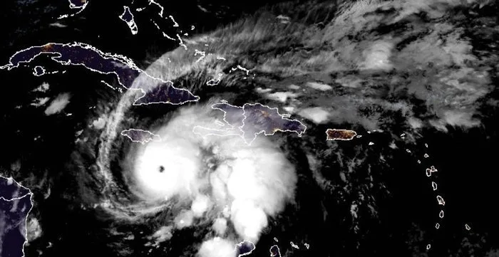
Hurricane Melissa could become a Category 5 hurricane just before it makes landfall in Jamaica on the evening of Oct. 27 or the morning of Oct. 28, the National Hurricane Center said.
The storm was still a Category 4 hurricane as of 5 p.m. ET on Oct. 26, boasting maximum sustained winds of 145 mph, but the National Hurricane Center forecast that those winds would reach 160 mph by the morning of Oct. 27.
As Melissa passes over Jamaica, it will begin to weaken but retain its status as a Category 4 with continued sustained winds of 130 mph over inland Jamaica by the afternoon of Oct. 28.
It is expected to continue to be a major hurricane as it arrives on the southeast Cuban coast, maintaining sustained winds of 120 mph and a Category 3 hurricane ranking on Oct. 29. A major hurricane is one that is a Category 3 (minimum sustained winds of 111 mph) or greater.
A storm has made landfall when the eye of the hurricane crosses onto land. The National Hurricane Center said that tropical storm conditions are likely occurring already on the island and that hurricane conditions are expected to arrive by Oct. 27.
Heading west at 5 mph, the storm’s center was tagged 115 miles from Kingston and 295 miles south-southwest of Guantanamo Bay. Tropical storm force winds (39 mph–73 mph) extend 205 miles out from the center, and hurricane-force winds (74 mph and greater) extend 30 miles out.
“Jamaica: seek shelter now,” the National Hurricane Center said in its forecast discussion on Oct. 26. “Damaging winds and heavy rainfall today and Monday will cause catastrophic and life-threatening flash flooding and numerous landslides before potentially devastating winds arrive Monday night and Tuesday morning.
“Extensive infrastructural damage, long-duration power and communication outages, and isolation of communities are expected.”
Kingston’s Norman Manley International Airport and Ocho Rios’ Ian Fleming International Airport closed on Oct. 25, and Montego Bay’s Sangster International Airport planned to close at 12:00 noon on Oct. 26.
The U.S. Embassy in Jamaica issued a statement warning U.S. citizens to be prepared to shelter in place, and said that it would only be available for limited emergency services from Oct. 27–Oct. 31.
Portions of Jamaica were forecast to get 15 inches to 30 inches of rain through Oct. 29, with an additional eight to 16 inches expected for southern Hispaniola. Some areas could receive 40 inches.
“Catastrophic and life-threatening flash flooding and landslides are expected across southwestern Haiti through midweek, likely causing extensive infrastructural damage and isolation of communities,” the center said in its forecast discussion. “Although winds are temporarily decreasing on the Tiburon peninsula, they could increase again across much of western Haiti on Tuesday.”
Southern areas of the Dominican Republic are also at risk.
The Jamaican government declared the island nation to be a threatened area under its Disaster Risk Management Act on Oct. 24, ahead of the disaster, triggering the deployment of necessary resources for emergency response and measures prohibiting price increases on essential goods such as food, water, and medical supplies.
“By declaring Jamaica a threatened area, we are activating the legal tools to move resources quickly, safeguard critical services, and protect the most vulnerable,” Jamaican Prime Minister Andrew Holness said in a statement. “This declaration enables the Government to act swiftly and decisively. I have directed all agencies to execute their preparedness plans, including shelter readiness and the pre-positioning of supplies and equipment.”
The National Hurricane Center also updated its forecast for Cuba in its 5 p.m. discussion on Sunday, noting that 10 to 15 inches of rain were expected through midweek, with some areas getting as much as 20 inches of rain.
“Life-threatening storm surge is expected along portions of the southern coast of eastern Cuba late Tuesday, and Tuesday night,” it warned. “Damaging winds and heavy rainfall with life-threatening and potentially catastrophic flash flooding and landslides are also expected beginning Monday. “Preparations should be rushed to completion.”
The Bahamas, and Turks and Caicos have also been advised to monitor the situation as Melissa’s heavy rains could cause significant storm surge, damaging winds and heavy rainfall on Oct. 28 and 29.
A travel warning was issued by the U.S. State Department.
“Consider departing the areas in the hurricane’s path now while flights are available and departure is still possible,” the State Department said in a travel warning to U.S. citizens. “If you choose to remain, be aware that flooding is likely in low-lying and flood-prone areas; avoid those areas or remain in a safe location until water recedes.
“Ensure emergency supplies are on hand including potable water, non-perishable foods, and fuel.”


