By Travis Fedschun | Fox News
A menacing Hurricane Dorian is taking aim at the northern Bahamas early Sunday, strengthening to a “catastrophic” Category 5 storm — packing winds of 180 mph and the threat of torrential rain that could last for days as millions in the U.S. along the Southeast coast from Florida to North Carolina are keeping an eye on where the storm may head next.
The National Hurricane Center as of 11 a.m. Sunday reported the center of the Category 5 storm was located around 20 miles east of Great Abaco Island in the Bahamas and 205 miles east of West Palm Beach, as it was moving west at 7 mph with maximum sustained winds of 180 mph.
NHC Director Ken Graham said that Dorian’s eyewall, where the strongest winds are located, is starting to reach the Bahamas.
“Right now one of the strongest storms in history for this region,” Graham said in a morning briefing.
NWS Austin/San Antonio✔@NWSSanAntonio
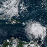
Satellite imagery this morning of now Category 5 Hurricane Dorian approaching the Abaco Islands in the northern Bahamas. For the latest on Dorian visit http://hurricanes.gov 5,8919:19 AM – Sep 1, 2019
Dorian is an “extremely dangerous” hurricane according to Fox News Senior Meteorologist Janice Dean, who said the storm is set to deliver a “devastating blow” to the northwest Bahamas Sunday through Monday.
“A perfect beast of a storm,” Dean said Sunday morning on “Fox & Friends,” adding that the northwestern Bahamas have never had a direct impact of a Category 5 storm before.
“This is not a storm to be messed with,” Dean added.
HURRICANE DORIAN’S PATH: WHAT YOU NEED TO KNOW
In the northern stretches of the Bahamas archipelago, hotels closed, residents boarded up homes and officials hired boats to move people from low-lying areas to bigger islands as Dorian approached.
Conditions were deteriorating rapidly in the Bahamas on Sunday morning. Video from ZNS Bahamas from 9:30 a.m. showed water rising as winds were picking up.
ZNS Bahamas@ZNSBahamas242
STORM WATCH: ZNS reporter Megan Shepherd on the ground in Abaco.
Winds are definitely picking up speed, water settling in the road. Residents are urged to take stay clear of the roads.#ZNSStormWatch #HurricaneDorian2019 #trackingDorian #ZNSOnline8510:18 AM – Sep 1, 2019
“The winds have definitely picked up. Trees are banging, they’re swaying. They’ve even breaking,” ZNS reporter Megan Shepherd said in a video posted to Twitter.
Another Twitter user posted a video to Twitter from a family member of the storm’s fierce winds reaching Abaco.
KajePlayz @KajePlayz
#HurricaneDorian has made it to Abaco7049:31 AM – Sep 1, 2019
Government spokesman Kevin Harris said Sunday that Dorian is expected to impact some 73,000 residents and 21,000 homes. Authorities closed airports for The Abaco Islands, Grand Bahama, and Bimini, but Lynden Pindling International Airport at the capital of Nassau remained open.
“There’s fear,” American Jack Pittard told the Associated Press in a phone interview Sunday morning as the eyewall approached the islands. “I’m worried about destruction of property, but I don’t believe there’s going to be loss of lives here.”
Pittard, who has been traveling to the Bahamas for some 40 years, told the AP he battened up his house and is spending his first hurricane in a nearby duplex behind a group of cottages that a friend owns. Pittard to the AP he didn’t expect significant storm surge in his location.
“I’m not afraid of dying here,” he said.

Workers board up a shop’s window front as they make preparations for the arrival of Hurricane Dorian, in Freeport, Bahamas. (AP Photo/Ramon Espinosa)
Forecasters warn that Dorian’s slow-motion may bring a prolonged period of life-threatening storm surge, devastating hurricane-force winds, and heavy rains capable of producing life-threatening flash floods on the Abaco Islands and Grand Bahama through Monday.
The NHC said that data at 9:30 a.m. from an Air Force Reserve Hurricane Hunter aircraft show the hurricane has continued to intensify.
National Hurricane Center✔@NHC_Atlantic
Extreme winds from the eyewall of #Dorian in excess of 180 mph will affect the Abaco Islands during the next few hours. TAKE COVER NOW! THIS IS AN EXTREMELY DANGEROUS AND LIFE-THREATENING SITUATION. Move immediately to the safe room in your shelter. http://hurricanes.gov 1,13410:57 AM – Sep 1, 2019
“The eyewall of catastrophic Hurricane Dorian is currently reaching the Abaco Islands. This is a life-threatening situation,” the NHC said. “Residents there should take immediate shelter. Do not venture into the eye if it passes over your location.”
NOAA Satellites PA@NOAASatellitePA
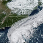
NEW: #NOAA20 captured this close-up of the eye of Category 5 #HurricaneDorian early this morning. @NHC_Atlantic now is describing this #hurricane as “catastrophic,” and forecast to bring life-threatening storm surge, devastating winds to the northwestern #Bahamas.
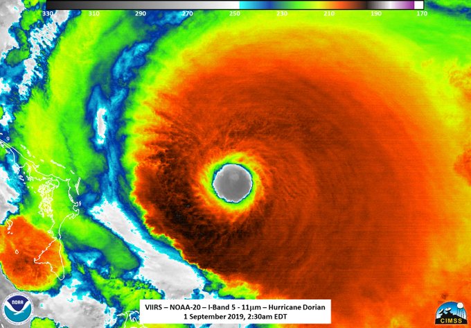
Between 12 to 24 inches of rain is forecast for the northwestern Bahamas, with isolated amounts up to 30 inches, according to the NHC. Dorian is also forecast to bring a life-threatening storm surge with water levels raised as much as 15 to 20 feet above normal in areas of onshore winds on the Abaco Islands and Grand Bahama Island.
“Near the coast, the surge will be accompanied by large and destructive waves,” the NHC said.
Florida Gov. Ron DeSantis asked Floridians to keep the Bahamas in their thoughts while also preparing for whatever impacts Dorian may bring. The Sunshine State declared a state of emergency last week ahead of the storm of assist with preparations.
Hurricane Dorian shifts closer to Florida coast
Janice Dean shares the latest forecast for Hurricane Dorian.
“The Bahamas are going to get absolutely leveled by this thing because this thing’s a strong storm. The Bahamas are flat,” DeSantis said Saturday. They got no defense to this storm and it’s going to churn over there; it’s going to dump perhaps 2 feet of rain on the Bahamas.”
DORIAN NEARS BAHAMAS BRINGING 150 MPH WINDS, THREAT OF STORM SURGE; TRUMP WARNS IT COULD BE AMONG ‘STRONGEST’ TO HIT IN DECADES
Bahamas Prime Minister Hubert Minnis warned that Dorian is a “dangerous storm” and said any “who do not evacuate are placing themselves in extreme danger and can expect a catastrophic consequence.”
Hurricane Dorian expected to drift along Florida’s East Coast Tuesday and Wednesday
Mayor Mark Bogen of District 2 in Broward County comments on safety preparations.
Small skiffs shuttled Saturday between outlying fishing communities and McLean’s Town, a settlement of a few dozen homes at the eastern end of Grand Bahama island, about 150 miles from Florida’s Atlantic coast. Most people came from Sweeting Cay, a fishing town of a few hundred people about 5 feet above sea level.
“We’re not taking no chances,” Margaret Bassett, a ferry boat driver for the Deep Water Cay resort, told the AP. “They said evacuate, you have to evacuate.”
The slow-moving storm may take until Monday afternoon to pass over the Bahamas, and then turn sharply and skirt up the U.S. coast, possibly staying just off Florida and Georgia on Tuesday and Wednesday and then affecting South Carolina and North Carolina on Thursday.
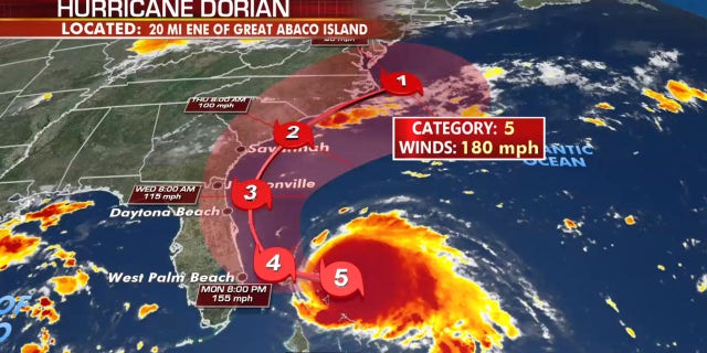
The forecast track of Hurricane Dorian. (Fox News)
But forecasters warn that Dorian’s path could easily shift and bring some of the worst conditions to coastal locations.
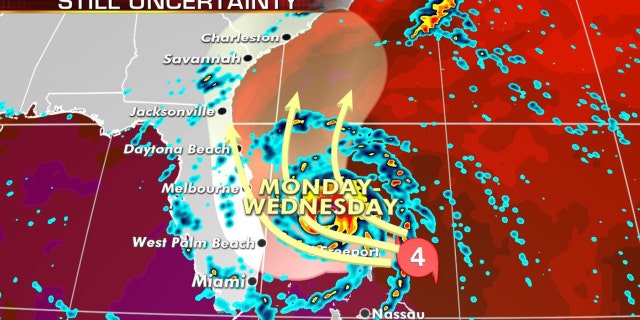
The uncertainties of where Hurricane Dorian could turn north and possibly impact the Southeast coast of the U.S. (Fox News)
“If there is a difference in the track by 30 miles, that’s the difference between tropical-storm-force and hurricane winds,” Dean said Sunday on “Fox & Friends.” That’s why we have to wait for every forecast.”
President Trump, who canceled his planned trip to Poland this weekend to monitor Dorian, said Sunday morning that in addition to Florida, South Carolina, North Carolina, and Georgia ill most likely be hit (much) harder than anticipated.
Donald J. Trump✔@realDonaldTrump
In addition to Florida – South Carolina, North Carolina, Georgia, and Alabama, will most likely be hit (much) harder than anticipated. Looking like one of the largest hurricanes ever. Already category 5. BE CAREFUL! GOD BLESS EVERYONE!14.8K10:51 AM – Sep 1, 2019
“Looking like one of the largest hurricanes ever. Already category 5,” Trump tweeted. “BE CAREFUL! GOD BLESS EVERYONE!”
In Florida, Palm Beach County issued the evacuation order beginning 1 p.m. Sunday after the county that includes West Palm Beach was placed under a tropical storm warning.
The evacuation includes barrier islands, mobile homes, and areas that are prone to flood because of Hurricane Dorian.
PBSO✔@PBCountySheriff · 1h
The eastern half of Palm Beach County is now under a Tropical Storm Warning due to the approach of #HurricaneDorian. Due to this, mandatory evacuations are being ordered for residential structures in Zone A and Zone B in Palm Beach County, effective at 1 P.M. Sunday, September 1.

PBSO✔@PBCountySheriff
Zone A includes mobile homes, sub-standard housing and low-lying areas prone to water intrusion.
Zone B generally includes the barrier islands, land areas north and south of the Jupiter Inlet, and other surge-vulnerable areas south along the Intracoastal Waterway to Broward.389:45 AM – Sep 1, 2019
While the official forecast path for Dorian curves the storm away from the area before it strikes land, the NHC said there is about a 50 percent chance West Palm Beach will get hurricane winds by early Wednesday.
On Saturday, South Carolina Gov. Henry McMaster declared a state of emergency, mobilizing state resources to prepare for potential storm effects. President Trump already declared a state of emergency and was brief late Saturday about the storm.
The hurricane upended some Labor Day holiday weekend plans in the U.S.: Major airlines allowed travelers to change their reservations without fees, big cruise lines rerouted their ships and Cumberland Island National Seashore off Georgia closed to visitors. Disney World and Orlando’s other resorts held off announcing any closings.
Fox News’ Melissa Leon and The Associated Press contributed to this report. Travis Fedschun is a reporter for FoxNews.com.


